NYS GIS Association News
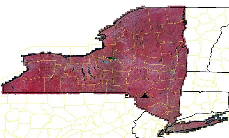
NAIP 2019 Orthoimagery Now Available for Download
NAIP 2019 Leaf-On Orthoimagery covering all of New York State is now available for download at https://nrcs.app.box.com/v/naip/folder/105431049956 Natural color and color infrared versions are available. Joe Beaulieu | ITS3, GIS Program Office, Public Safety Portfolio...

Esri releases a collection of Coronavirus Response ArcGIS Solutions
Esri has just released a collection of Coronavirus Response ArcGIS Solutions. These are free, configurable, supported, open source GIS applications that can be deployed quickly using the ArcGIS Pro Solution Deployment Tool. They are all powered by ArcGIS Online....

NYS GIS Program Office Civil Boundaries Update
New versions of NYS Civil Boundaries and NYS Place Points datasets were published last month (February) and are both available as: GDBs and SHPs for download here at gis.ny.gov. Place Points can be downloaded here Map services (Feature Service, WFS, Map Service and...
Updated NYS Hydrography Web Service
Hello, The New York State GIS Program Office (NYSGPO) is pleased to announce that we updated the web service for hydrography data in New York State. This hydrography dataset is a subset of the National Hydrography Dataset (NHD) that loads filtered subsets of the NHD...

Resources for tracking and surveilling Coronavirus COVID-19
Good morning all, Here at Esri we have been fielding an extreme number of questions and inquiries from PH and EM organizations on a state and local level regarding COVID 19 situational awareness, especially “What are other EM’s doing?”. We thought it would be a good...

NYSGPO Building Footprint Web Service!
Hello, The New York State GIS Program Office (NYSGPO) is pleased to announce the release of a web service that hosts over 3 million building footprints across 30 counties made available by the New York State Energy Research and Development Authority (NYSERDA). ...
Collection of GeoInspirations Interviews of Women to help Celebrate International Womens’ Day
NY GIS Community: https://www.directionsmag.com/playlist/8618 — The above subset of the GeoInspirations column interviews I have conducted over the past five years for Directions Magazine contain some particularly inspiring geo-women, stories that you can share with...

eSpatiallyNY- The Definitive Map for New York State Media Arts
The latest post from NYS GIS Association member Sam Wear, “eSpatiallyNY- The Definitive Map for New York State Media Arts”, posted February 25, 2020, is available on his website eSpatially New York. "At its core, the Map is an extensive online catalogue of Media...

NY GIS User Group
We would like to invite you to a free Esri ArcGIS User Seminar & Workshop at the Hyatt Regency Rochester in Rochester NY, on Friday March 20th, at 8:00am – 4:00pm. We will be presenting this one-day Seminar and Workshop in various locations around the country...

NYC School of Data 2020 (Mar 7)
NYC School of Data is BetaNYC’s annual community-driven conference — with programming support from NYC Mayor's Office of Data Analytics, we bring together city officials, activists, and community members to talk about open data, civic technology, and service design....
 Open Source GIS
- Notebooks in QGIS 01/10/2026
- QGIS to (Geo)Pandas – part 3 12/03/2025
- QGIS to (Geo)Pandas follow-up 10/31/2025