Emerging GIS Resources
Emerging GIS Resources
What’s It All About?
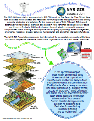
The NYS GIS Association was awarded a $10,000 grant by The Fund for The City of New York to assess the GIS needs and resources for municipalities throughout NYS and identify potential strategies and solutions for the increased use of GIS. Although GIS is used extensively in many areas, there are still places in New York state that do not use GIS or could use it more effectively. This page provides a central repository of resources that are available to anyone wanting to learn more about growing GIS in New York state.
 Support provided by the Fund for the City of New York
 Informational Flier
GIS Return on Investment Calculator
The NYS GIS Association in collaboration with the Fund for City of New York has developed GISCalc, an Excel return-on-investment tool. GISCalc allows you to quickly estimate the benefits to your jurisdiction of using GIS. The formulas in GISCalc are based on a hundred documented GIS applications which were grouped into benefit categories, and whose ROI metrics were extracted for use in the model.
GISCalc allows you to adjust inputs based on easy-to-find characteristics of your own jurisdiction. It also allows you to either accept default benefit factors or to customize them as you wish. There is a worksheet included where you can also factor in costs. You may run GISCalc as many times as you wish to gauge benefits according to different benefit and cost scenarios.
Please take GISCalc for a spin and see if it provides you with useful information. We want to know if you found GISCalc helpful and whether you have recommendations for improvement. Please provide feedback or requests for assistance by using the Contact Us page.
We’d like to thank Paul Epstein and Brett Whysel for their work in designing GISCalc. Thanks also to Dr. Mary McCormick, President of the Fund for the City of New York for providing the funding that made the development of this tool possible.
Real Project Descriptions
Interviews were conducted with New York State County and Municipal GIS Leaders
Video Series
State of the State in GIS
Presented by William Johnson, Geographic Information Officer (GIO) for New York State
A CIO Perspective on Integrating Geo-Information Systems into IT by Alan Leidner
Introduction
As an everyday part of their jobs, CIOs of large county and city governments must integrate an ever-growing and evolving variety of capabilities and technologies to ensure the effective management of computer systems serving the needs of their jurisdictions. Over the past years, CIOs have had to contend with rapidly advancing Internet services, new generations of software and programming languages, high speed telecommunications technologies, wireless communications, cloud computing, making sense of social media generated “big data”, cyber security, building information management (BIM), smart infrastructure, and a proliferation of mobile devices and PDAs. Also, ever since microcomputers sparked an explosion of computer use outside the jurisdiction of the centralized mainframe world, CIOs have had to deal sensitively with a complex environment where agency-based IT managers who did not come under the CIO’s direct control have a major hand in implementing departmental systems. Into this challenging environment, CIOs are also increasingly contending with geospatial information systems (GIS), trying to find the optimal balance between central control and laissez faire policies. The purpose of this chapter is to explore the synergies between central IT and GIS, and the role of the CIO in maximizing and measuring their benefits.
Copyright PTI. “CIO Leadership for Cities & Counties – Emerging Trends and Practices”; second edition; to be published May 2016.
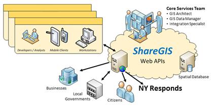
NYS ShareGIS
Authoritative GIS data and tools should be easy to discover, understand and available for use by all. The GIS Core Services team has embarked on an initiative to build the ShareGIS environment in answer to the need for a statewide GIS Platform. More..